IAMD COE is located at the Akrotiri peninsula 13km from the historical city of Chania. Chania is the second largest city of CRETE and the capital of the CHANIA regional unit. It lies along the north coast of the island, about 70 km (43 mi) west of RETHYMNO and 145 km (90 mi) west of HERAKLION.
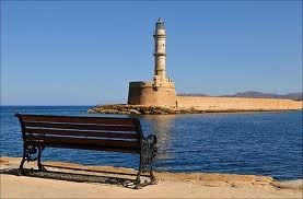
The city of Chania can be divided into two parts: the old town and the modern city which is the larger one. The old town is situated next to the old harbor and is the matrix around which the whole urban area was developed. It used to be surrounded by the OLD VENETIAN FORTIFICATIONS that started to be built in 1538, but only the eastern and western parts have survived. From the south, the old town is continuous with the new, and from the north the physical border is the sea. The centre of the modern city is the area extending next to the old town and especially towards the south.
THE ARCHAEOLOGICAL MUSEUM

Tel.: +30 28210 90334
e-mail: efacha@culture.gr
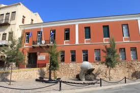
The Archaeological Museum of Chania is in Chalepa, a historic suburb in Chania, housed in an iconic building constituting a landmark for the whole city. The museum’s permanent collection is developed in three main halls on the ground floor and one more on the first floor, presenting the wealth of archaeological material that has been retrieved from the periphery of Chania through the course of time. The collection of the museum includes findings from excavations in several areas of the city that have been performed during the last 50 years, and its exhibits cover the cultural history of Chania from the Neolithic period till the Roman Empire. All of the exhibits are placed according to the subject or the location where they were found. The Archaeological Museum of Chania organizes temporal exhibitions, educational programs, and various cultural events during the whole year in order to protect the cultural history of Chania in the best possible way, constituting an attraction for many visitors.
THE NAUTICAL MUSEUM OF CRETE IN CHANIA
Tel.: +30 28210 – 91875
Fax: +30 28210 74484
e- mail :Mar-museum-crete@otenet.gr
The Nautical Museum of Crete is located at the entrance of the historical fortress “Firka”. It was founded in 1973 in order to promote the nautical traditions and history of the island. The Museum cooperates and interacts with other Nautical Museums in Greece and abroad.
The permanent exhibition includes 2.500 items, such as relics, objects found in the bottom of the sea, paintings, maps, photographs, models of ships, nautical equipment etc. The exhibits are organized in units, in chronological order from the Copper Age until today. There is also a special exhibition of sea environment, with a rich collection of shells from different places of the world.
An important development step for the Nautical Museum is the creation of a permanent exhibition of ancient and traditional shipbuilding. The main exhibit of the museum is the reconstructed Minoan ship “Minoa” an experimantal model, faithful copy of the original ancient commercial ship. Other exhibits are the tools and the materials that were used for its manufacture, some photographs and a map of its experimental travel.
THE TYPOGRAPHY MUSEUM OF CHANIA CRETE
Tel.: +30 28210 80091
E-Mail: info@typography-museum.gr
Url: www.typography-museum.gr
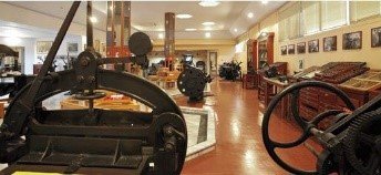
The sole Museum of Typography in Greece is located in Chania, only 4 km from the city of Chania, in the Industry Park of Souda.
The Museum of Typography, which officially opened its gates in May 2005, includes in its collection fine printing presses and other machines, as well as tools and objects that present the development of typography from its birth, the period of Gutenberg till today.
Rare books and newspapers, as well as precious lithographies, travel the visitor in the art of Typography. The effort for the enrichment of the Museum with new exhibits and the contact with people of Typography is continuous. In April 2012, the museum was extended in a new wing, adding exhibits in its collection that concern the development of graphic arts, as well as two significant exhibitions that are related with the development of typography and the history of writing. During the visit can everyone print using the old printing press.
Museum of Eleftherios Venizelos
Tel.: +30 28210 56008 / +30 28210 51555-6
E-mail: info@venizelos-foundation.gr
Url: www.venizelos-foundation.gr/house
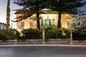
The fatherly house of Eleftherios Venizelos in Halepa of Chania, which constituted his house for more than thirty years, from 1880 to 1910 and later for short periods from 1927 to 1935, today constitutes a Museum under the responsibility of “National Institution of Researches and Studies El. Venizelos”, in which it has been granted by the Greek state.
The collection of the Museum consists of the complete household effects of the ethnarch, which he personally selected, from works of art, part of his library, his personal objects and from the collection of objects and records of Institution, relative to the period, the action and the personality of Venizelos. Characteristic is also that all the areas of the residence have maintained their authentic form until today, the one that they had during the period that El. Benizelos lived at the house.
SAMARIA GORGE NATIONAL PARK
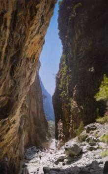
The Samariá Gorge is a NATIONAL PARK of GREECE the island of CRETE – a major tourist attraction – and a WORLD’S BIOSPHERE RESERVE.The gorge is in southwest Crete in the regional unit of CHANIA. It was created by a small river running between the White Mountains (Lefká Óri) and Mt. Volakias. While some say that the gorge is 18 km long, this distance refers to the distance between the settlement of Omalos on the northern side of the plateau and the village of AGIA ROUMELI. In fact, the gorge is 16 km long, starting at an altitude of 1,250 m at the northern entrance, and ending at the shores of the Libyan Sea in AGIA ROUMELI.
The actual walk through Samaria National Park is 13 km long, but one has to walk another three kilometers to AGIA ROUMELI, making the hike 16 km long. The most famous part of the gorge is the stretch known as the Gates (or, albeit incorrectly, as “Iron Gates”), where the sides of the gorge close in to a width of only four meters and soar up to a height of almost 300 meters (1,000 feet). The gorge became a national park in 1962, particularly as a refuge for the rare KRI-KRI (Cretan GOAT), which is largely restricted to this park (and on an island just off the shore of AGIA MARINA). There are several other ENDEMIC SPECIES in the gorge and surrounding area, as well as many other species of flowers and birds.
The village of Samariá lies just inside the gorge. It was finally abandoned by the last remaining inhabitants in 1962 to make way for the park. The village and the gorge take their names from the village’s ancient church, Óssia María.
It is a ‘must’ for visitors to Crete to complete the walk down the gorge from the Omalos plateau to Agia Roumeli on the Libyan Sea, at which point can sail to the nearby village of HORA SFAKION and catch a coach back to Chania. The walk takes five to seven hours and can be strenuous, especially at the peak of summer.
Local tourist operators provide organized tours to the Gorge. These include bus transportation from one’s hotel to the entrance (near Omalos village), and a bus connection that will be waiting for hikers after they disembark the ferry in Sfakia (Chora Sfakion). If you are on your own, you can make a one-day round trip from Chania (see below) or from Sougia or Paleochora. Note that the morning buses from Sougia and Paleochora do not operate on Sunday. The ferries leave Agia Roumeli to Chora Sfakion (eastbound) and to Sougia/Paleochora (westbound) at 17:00.
There also exists a “lazy way” – from Agia Roumeli to the Gates, and back
The graves of Venizelos family

The graves of Venizelos family is one of the most popular places that offer a panoramic view of Chania, only a few kilometres east of the city, on the road to Akrotiri and airport. Here are located the graves of the charismatic Greek politician, and seven times Prime Minister of Greece, Eleftherios Venizelos, and his son, Sofoklis Venizelos, who was also Prime Minister of Greece from 1943 to 1952.
Nearby is located the small church of Profitis Ilias and the statue of Spyrus Kagialedakis or Kagiales, who on February 9, 1897 (Revolution of 1897), during the bombing of the revolted Cretans by the fleet of the great forces, he made his body flagstaff to raise the Greek flag that had been dropped by the bombshells of the ships.
CHANIA OLD TOWN
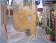
The “Old Town” consists of the old Venetian harbor and the small Venetian blocks located behind the harbor; it is characterized by narrow and picturesque alleys – similar to an enchanting labyrinth – full of life, and the plentiful remaining Venetian and Turkish buildings.
A unique city bearing a rich and long history and culture. The old city of Chania build over the ruins of ancient city of KYDONIA has managed to preserve its cultural heritage and traditional architecture. Nowdays the city has 100.000 residents. Its rare beauty justifies its characterization as the “Venice of the East”
There are also plenty of cafes and local restaurants where you can enjoy traditional dishes.It is worth wandering through the narrow streets as is is an experience that you will remember for long .
In the following links you can find useful information about the city of Chania.
https://www.chaniatourism.com/
KNOSSOS
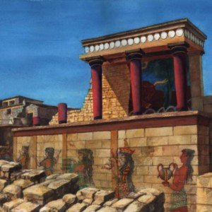
Knossos is the largest BRONZE AGE ARCHAEOLOGICAL SITE on CRETE and considered as Europe’s oldest city.
The name Knossos survives from ancient Greek references to the major city of Crete. The identification of Knossos with the Bronze Age site is supported by tradition and by the Roman coins that were scattered over the fields surrounding the pre-excavation site, then a large mound named Kephala Hill, elevation 85 m (279 ft) from current sea level. Many of them were inscribed with Knosion or Knos on the obverse and an image of a MINOTAUR or LABYRINTH on the reverse, both symbols deriving from the myth of King MINOS, supposed to have reigned from Knossos. The coins came from the Roman settlement of Colonia Julia Nobilis Cnossus, a Roman colony placed just to the north of, and politically including, Kephala. The Romans believed they had colonized Knossos.[6] After excavation, the discovery of the LINEAR B tablets, and the decipherment of Linear B by MICHAEL VENTRIS, the identification was confirmed by the reference to an administrative center, ko-no-so, Mycenaean Greek Knosos, undoubtedly the palace complex. The palace was built over a Neolithic town. During the Bronze Age, the town surrounded the hill on which the palace was built.
The palace was excavated and partially restored under the direction of ARTHUR EVANS in the earliest years of the 20th century. Its size far exceeded his original expectations, as did the discovery of two ancient scripts, which he termed LINEAR A and LINEAR B, to distinguish their writing from the PICTOGRAPHS also present. From the layering of the palace Evans developed de novo an archaeological concept of the civilization that used it, which he called Minoan, following the pre-existing custom of labelling all objects from the location Minoan.
The palace of Knossos was undoubtedly the ceremonial and political centre of the MINOAN CIVILIZATION and culture. It appears as a maze of workrooms, living spaces, and storerooms close to a central square. An approximate graphic view of some aspects of Cretan life in the Bronze Age is provided by restorations of the palace’s indoor and outdoor MURALS, as it is also by the decorative motifs of the pottery and the insignia on the seals and sealings.
The palace was abandoned at some unknown time at the end of the Late Bronze Age, ca. 1380–1100 BC. The occasion is not known for certain, but one of the many disasters that befell the palace is generally put forward. The abandoning population were probably Mycenaean Greeks, who had earlier occupied the city-state, and were using Linear B as its administrative script, as opposed to Linear A, the previous administrative script. The hill was never again a settlement or civic site, although squatters may have used it for a time. Except for periods of abandonment, other cities were founded in the immediate vicinity, such as the Roman colony, and a Hellenistic Greek precedent. The population shifted to the new town of Chandax (modern HERAKLION) during the 9th century AD. By the 13th century, it was called Makruteikhos ‘Long Wall’; the bishops of GORTYN continued to call themselves Bishops of Knossos until the 19th century. Today, the name is used only for the archaeological site now situated in the expanding suburbs of Heraklion.